


dent du chat depuis le col

yonel
User
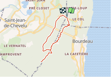

Length
6.3 km

Max alt
1267 m

Uphill gradient
645 m
Km-Effort
14.9 km

Min alt
616 m

Downhill gradient
645 m
Boucle
Yes
Creation date :
2024-03-11 19:55:06.081
Updated on :
2024-03-11 19:55:08.605
3h22
Difficulty : Medium

FREE GPS app for hiking
 SityTrail
IGN / Geographical institutes
SityTrail Plus
The world is yours!
About
Trail Walking of 6.3 km to be discovered at Auvergne-Rhône-Alpes, Savoy, La Chapelle-du-Mont-du-Chat. This trail is proposed by yonel.
Positioning
Country:
France
Region :
Auvergne-Rhône-Alpes
Department/Province :
Savoy
Municipality :
La Chapelle-du-Mont-du-Chat
Location:
Unknown
Start:(Dec)
Start:(UTM)
721708 ; 5063874 (31T) N.
Comments